

Murray Wood: Who's most likely to be hesitant about vaccines? Some won't like the findings
Murray Wood says a survey finds certain groups are more likely to be leery of vaccines, and it likely has something to d...
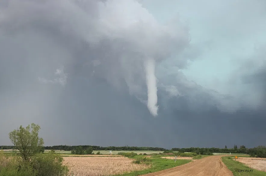
South-central parts of Saskatchewan can expect rain, thunderstorms and potential for funnel clouds on Wednesday, according to Environment and Climate Change Canada (ECCC).
Danielle Desjardins, warning preparedness meteorologist with Environment Canada, said there was an “unstable air mass” over the southern and central parts of the province.
“We are expecting shower and thunderstorm activity this afternoon,” Desjardins said on Wednesday morning in an interview.
Read more:
She said conditions are “ripe for the potential for funnel clouds or maybe even a brief touchdown,” as well.
“Under these circumstances, we’re not looking at violent tornadoes,” Desjardins clarified. “This would be a brief touchdown, if anything.”
Specifically, cold core funnel clouds are being called for by the weather office. Desjardins said these are a type of funnel cloud that occur very briefly when thunderstorms are just starting to develop and the atmosphere is unstable to the point where, as a storm begins, the funnel cloud could form.
“It’s not the same as the classic supercell thunderstorms that produce violent tornadoes, so that’s the difference between a day like this, as opposed to a day where we’re expecting super cell thunderstorms with the potential for more violent tornadoes,” she said.
She said that should a funnel cloud touch down, it could toss around loose objects or cause minor damage but are generally harmless occurrences.
She said some sub-severe wind gusts – with Desjardins noting the threshold for a “severe” wind gusts around 90 kilometres an hour or sustained 70 km/h gusting to 90 km/h – might actualize. If a funnel cloud does touch down, she said swirling winds would produce circulation at the surface which could pick up dust and toss loose objects. That would be localized and brief, she explained.
The potential for this weather in Saskatchewan covers a lot of the south central portion of the province. Desjardins estimated between the Yellowhead and the Trans Canada highways and areas that have been experiencing the “kind of gloomy, showery weather over the last several days” might have the highest potential to see worse storm activity.
However, any part of the province within where the weather statement has been issued has a chance of seeing more intense weather on Wednesday.
“Bigger energy” for more severe weather is further east, into southern Manitoba, she said.
This system is comprised of remnants of the low that brought heavy precipitation to Alberta, Desjardins shared.
“It’s … very slow moving low, and it is weakening,” she said, that will be travelling east throughout the duration of the day.
“Once this clears out, there will be some more instability coming for the weekend for southern Saskatchewan, with more chances of showers and thunderstorms,” though sunshine during the daytime hours will be possible, around risks of showers and thunderstorms in the afternoons and evenings, Desjardins said.
–with files from 980 CJME’s Abby Zieverink


")