

Murray Wood: Who's hot... and who's not
Every Friday, Murray Wood takes a look back at the week's news and decides who's hot... and who's not.
Environment Canada is looking into a tornado report that may have touched down near Colfax, southeast of Regina.
It comes as severe thunderstorm warnings and watches were issued on Sunday, with one warning changing into a tornado warning around Lang, Yellow Grass, and Lewvan.
Meteorologist Eric Dykes said they are looking into a possible tornado near Colfax, about 70 kilometres southeast of Regina, shortly after 5 p.m. on Aug. 17.
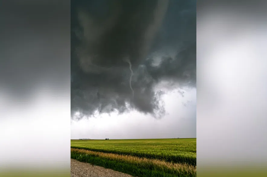
“It was a very, very skinny looking tornado, a little bit hard to discern in the pictures as to whether or not there was an actual touchdown on the ground, per se from the picture, but the the funnel itself, the majority of the funnel was rather lengthy and winding and narrow, so certainly looks to be what it certainly looks to be one of a smaller tornado.”
Better video of funnel near colfax. Pretty looking skinny funnel would of been photogenic if didn't die out.
Around 5pm #skstorm pic.twitter.com/tnYozuBcbq
— Mitch Healey (@MitchHealeyPics) August 18, 2025
As of Monday morning, Dykes said they are not hearing about any damage from the possible tornado.
However, he said, because it was so skinny, if it did touchdown, it likely didn’t cause much damage.
“When investigators go and look out for that tornado later on, and we’ll probably see that there’s probably not gonna be a whole lot of damage with that, especially pertaining to the crops and so forth,” said Dykes.
“Normally, when we see a lot of damage, it’s a very fat-looking tornado, very thick-looking tornado, very robust; those are the ones that normally are your category, EF fours and fives and so forth.”
Read more:
Dykes said further south, there was also a report of two or three funnel clouds near Tribune, which is west of Estevan. He said that was from a separate storm from the one that produced the possible tornado.
Meanwhile, more stormy weather is expected on Monday in parts of Saskatchewan.
“There are some very weak features that are moving through the province today, one through West Central Saskatchewan. It’s going to be cutting through the north of Kindersley, from North Battleford, into the Meadow Lake areas prominently, west of Saskatoon.”
“If storms do initiate up there, there’s a possibility that we could see some large hail, perhaps some heavy rains and strong winds.”
On top of that storm, Dykes said more storms could occur in the far southeast corner of the province.
“In that environment, it’s a little bit different from further to the northwest; what we’re expecting more so from those storms might be just large hail and heavy rains.”


")