

Murray Wood: All hail the placekicker! Except when he misses
Alex Hale was supposed to make us forget about Brett Lauther, but how can we? Murray Wood says Hale has struggled, while...

Get ready to pull out the shovels and snowblowers on Tuesday, as a big dump of snow is set to hit much of Saskatchewan.
Snowfall warnings and blowing snow advisories from Environment Canada covered much of southern and central Saskatchewan on Tuesday morning. Meteorologist James Colangelo said quite a bit of snow is expected to fall over the next 24-36 hours, with the snowfall expected to start in Regina and Saskatoon on Tuesday afternoon before ending on Wednesday evening.
Read more:
“It looks like that warm spell is over with this winter storm here, and then back to winter as we know it,” Colangelo said.
Up to 35 cm of snow is expected to fall in areas between Meadow Lake and Estevan by Wednesday evening. Colangelo said Regina could get as much as 30 cm of snow, while Saskatoon could see as much as 25 cm.
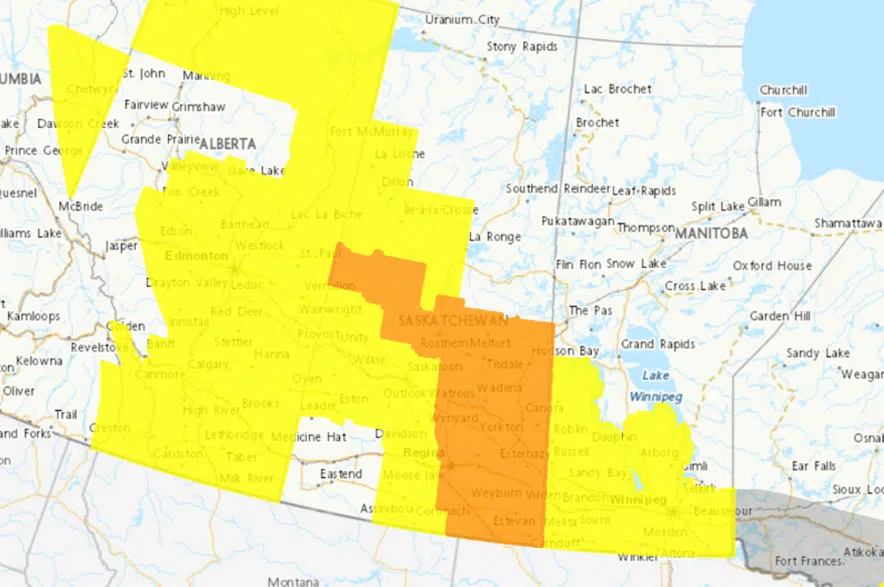
Large areas of Saskatchewan were under snowfall warnings and blowing snow advisories from Environment Canada on Tuesday morning. (Environment Canada)
“That could make your rush-hour commute home tonight really, really treacherous,” said Colangelo. “The roads will be a little bit slick with that snow. Just be careful out there. Avoid non-essential travel, if possible.”
Colangelo said wind gusts up to 80 km/h are expected in the Regina area on Tuesday afternoon, and gusts up to 60 km/h are expected in the Saskatoon area. He said he expects highway conditions to deteriorate as the weather system moves into the province, with zero visibility at times.
“Expect really treacherous driving conditions. If you’re out on the roads, really be careful. Keep a large following distance behind the car in front of you, because that snow will be blowing quite a bit,” the meteorologist advised.
“If I were a betting man, I’d expect some road closures today, and possibly pretty widespread. So as the system really extends all the way up from the international border up north of Saskatoon to Prince Albert, I’d expect quite a few road closures.”
Colangelo said the winds will peter out well before the snow stops falling.
“The winds will start to die off well before the snow does, but you won’t be out of the woods in terms of that heavy snowfall,” he said.
Once the system rolls out of the province, Colangelo said temperatures in the -20 C range are expected to make a return to the province.
The latest updates on the weather alerts can be found on Environment Canada’s website, and current road conditions can be accessed via the Saskatchewan Highway Hotline.
In an update on Tuesday afternoon, Environment Canada warning preparedness meteorologist, Danielle Desjardins, offered some slight adjustments to the original forecast.
She estimated Tuesday night’s initial storm will bring roughly 15 to 20 cm, or roughly 8 inches, of snow to Saskatoon.
For Regina, the city will see that snowfall amount sit around 25 cm or roughly 10 inches throughout Tuesday night. Saskatchewan, generally, will also see some strong winds over the next day or two. Desjardins said the southeast, specifically, will see the biggest impact.
“The winds are quite a bit stronger in the Wascana basin in southeastern Saskatchewan — we’re seeing gusts of 80 to 90 kilometres an hour,” she said.
She said that a mix of both snow and wind could make for a dicey few days of road conditions.
“Both cities could see some periods of blowing snow and near zero visibility, and with the rapidly accumulating snow,” she said. “Expect very poor travel conditions.
“If you can delay travel, do so,” Desjardins advised. “If you must go, check the Highway Hotline for the latest road conditions and leave enough time to get to your destination safely.”
City of Regina crews are on standby, ready to tackle the incoming snowstorm heading towards Regina.
The Saskatchewan RCMP is warning drivers about difficult conditions and reduced visibility on several Saskatchewan highways, advising the public to avoid any non-essential travel until conditions approve.
“If travel is necessary, stay on roads that have recently received road maintenance,” the police force advised.
The RCMP said Highway 6 between Watson and Raymore is in rough shape, with “near-zero visibility” due to blowing snow.
“There are reports of a number of vehicles in the ditch and a semi across the highway. Please avoid the area if possible and slow down if you must travel there,” the RCMP said in a statement.
Meanwhile, the Mounties said Highway 20 between Humboldt and Lanigan is clear after being blocked earlier in the day, but conditions on that stretch are “still very poor.”
As of 8 p.m. on Feb. 17, the Highway Hotline showed snow and low visibility impacting conditions on most roads throughout Saskatchewan.
Travel was not recommended on many highways throughout central Saskatchewan and around Regina, including the Regina Bypass. Highway 11 between Regina and Lumsden is also listed as travel not recommended by the Highway Hotline.


")